New Job - Different Earthscience Informatics Applications

Well, on April 1, 2019, I started a new position with the Ohio Geological Survey (Ohio Department of Natural Resources, Division of Geological Survey) as a Geology Program Supervisor in the Energy Resources Group. The Energy Resources Group deals mostly with energy resources research, general subsurface geology and geophysics, and geologic carbon capture, utilization, and storage (CCUS). I currently have a team of four geologists who work for me - backgrounds in conodont biostratigraphy and chronostratigraphy, petroleum geology and structural geology, and geochemistry and igneous and metamorphic geology.
Previously, I was the GIS Systems Administrator for the Ohio Department of Natural Resources, Office of Information Technology. There, I led a team GIS professionals, including a GIS Database Administrator, a GIS Applications Developer, and two GIS Specialists.
April 1, 2020 will mark the one-year anniversary of my returning to the Ohio Geological Survey. As many of you know, a large portion of career has been involved in GIS and data management, which in a larger sense are part of earth science informatics. I thought I would occasionally write some articles on projects that I have worked on in the past, projects that I am currently working on, and observations and general trends in earth science informatics.
One of the first things that I did when I returned to the Ohio Geological Survey was a project to release the geophysical logs to the public as free downloads. As many of you know, during the course of drilling an oil and gas, or sometimes a water well, geophysical logs are taken either during or after the well is drilled. For those of you who are not familiar, geophysical logs are instruments lowered through oil and gas well bores, which measure various rock properties, such as porosity, and allow for identification of different types of rocks. The logs form a key dataset used by industry for oil and gas exploration, by government agencies for environmental restoration and remediation, and by academic institutions for research.
The Ohio Geological Survey is the state archive for all geophysical logs taken in Ohio. Currently, it has over 138,000 log files (for over 80,000 wells) available for oil-and-gas wells located throughout the state, some of which date back to 1947. There are also a handful of geophysical logs for water wells that are available. The files are primarily image files (TIF format). For a limited number of wells, the geophysical logs are in Log ASCII Standard format (LAS files). The LAS files are more valuable since they contain the raw measurements and can be used for calculating rock and fluid properties.
When I got back to the Ohio Geological Survey, I told my supervisors, State Geologist Mike Angle and Assistant State Geologist JD Stucker, that I wanted to start a project to release the geophysical logs to public for free download AND it would only take 1-4 hours of software developer/database administrator time. Since I was previously with the ODNR – Office of Information Technology as a GIS Systems Administrator prior before moving to the Survey, I knew that we had all the components ready to release the data to the public. All the logs had been scanned or converted to LAS format. All the logs had been indexed into database tables. At that point, releasing the data to the public was a few hours of database work and application modification by a software developer. Mike and JD said go ahead, and within a short period of time, the data was available.
Here is a general guide to accessing/downloading the geophysical logs:
Go to the Oil and Gas Wells Interactive Map: https://gis.ohiodnr.gov/MapViewer/?config=OilGasWells
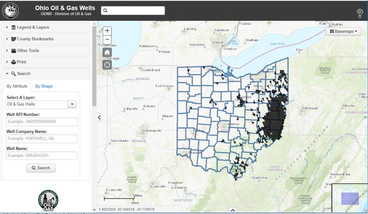
On the Interactive Map, you may want to turn on and turn off some
layers prior to searching on the map. My suggestions would be to turn off
the Source Water Protection Area (OEPA) layer, turn off
the Notification Area layer, and under the Oil and Gas
Wells group, turn on the Wells by Status (Inactive). Normally,
only the active wells are displayed on the map.

Once in the map, you’ll need do a search by API number to access
the geophysical logs that you want. For example, let’s search
for 34029217200000.

Left click on the selected well. When you do the left click, up
will pop-up an Identification box. In that Identification box, there will be a
link to the Well Summary Report. Click on that link.

You will then get the Well Summary Report. At the bottom of the
report will be the geophysical logs (Scanned TIFs and LAS files)
available for download.

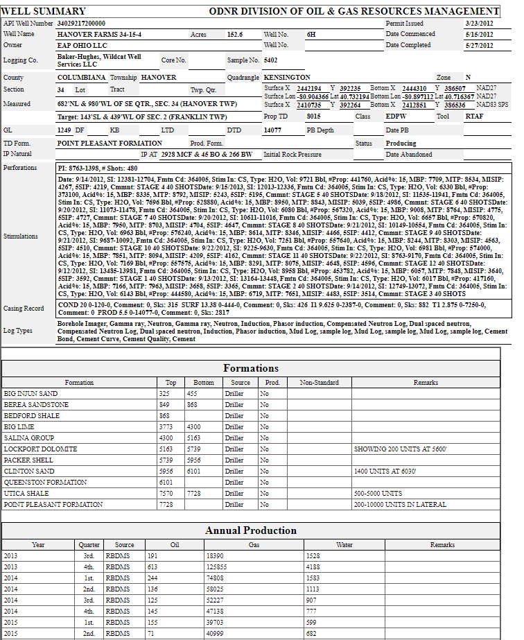
You can see in this example there are five logs available
for download for this Utica well. The text (.tif) is an indicator that there
are more logs that have been scanned and are undergoing the QA/QC
process prior to the public release.
You can also access the Well Summary Report for each well by
substituting the API number in the URL string. For example: https://gis.ohiodnr.gov/MapViewer/WellSummaryCard.asp?api=34029217200000,
will bring up the Well Summary Report for 34029217200000.
For example, if you change the API number in the string to 34029206680000
(https://gis.ohiodnr.gov/MapViewer/WellSummaryCard.asp?api=34029206680000),
you will get the Well Summary Report for a Rose Run Sandstone well drilled in
1972, and which also has scanned TIF files and LAS files for the geophysical logs.
The scanned log index and the LAS log index are also available through the Interactive Map as spreadsheet files. Once you open the Oil and Gas Well Interactive Map, a splash screen will show up. In the splash screen, there will be a DATA tab. Click on that Tab to access the index files showing what geophysical logs are available, along with all the GIS data that is available for download. If you accidently close the splash screen, you can easily open it again by clicking on the "?" in the upper right-hand corner of the Interactive Map.
Finally, I like to say thanks to Joe Wells, Geospatial Database Administrator, Khanh Pham, Senior Software Developer, and Mark Anstaett, GIS Software Developer, for making this project happen.
Go ahead and explore!


Comments
Post a Comment